Having in-depth expertise in the full range of 2D, 3D, 4D, wide azimuth and VSP operations, IES provides support across all aspects of land, marine, transition zone, OBC, OBN seismic operations in any environment.
Our skills cover the technical and HSE aspects of seismic programs. Customers can use this expertise either as a stand-alone service or as multidisciplinary package based on their current needs.
We maintain the flexibility and individual approach that our customers require, whilst also having the right resources to respond quickly to any requests of the customer.
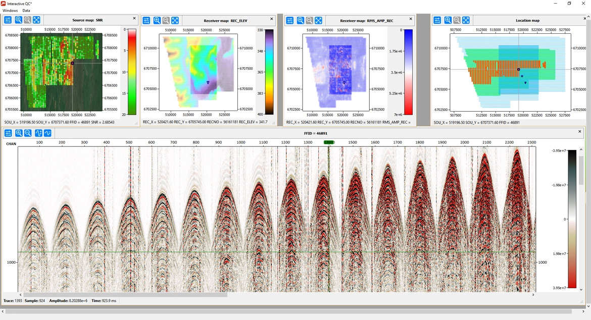
High quality seismic data requires that all established acquisition parameters are strictly followed and equipment is functioning as per the specification. Seismic Quality Control is an important element in ensuring that data are acquired correctly. By placing highly qualified QC specialists in the field we ensure that the customer's interests are properly represented on seismic crews and vessels.
We have personnel experienced in land, marine, transition zone projects and VSP surveys. Our expertise covers 2D, 3D, time lapse (4D), ocean bottom cable (OBC), ocean bottom nodes (OBN), multicomponent (4C) seismic projects.
Another important element of our services is the provision of independent technical audits. IES audit engineers possess years of experience with different seismic instrumentation, who use independent test equipment and software to check that recording equipment operates to the manufacturer's and contractual specifications. IES has also instrument analysis software to enable the tests to be processed on-site.
Navigation and positioning are an essential component in ensuring optimum quality seismic data. IES has positioning experts for both land and marine surveys. Onshore, surveyors provide QC and positioning/survey control audits. The surveyor monitors survey operations and audits equipment and procedures and ensures that all data are correctly linked to seismic trace information. Offshore, we provide experienced navigation QC personnel and on-board QC systems to run in parallel with the contractor's system providing real time QC and verification of navigation integrity.
We also offer office-based navigation processing QC. Our engineers receive the positioning data daily and process them in-house, providing verification that positioning data are correct and that all parameters are in conformance with contractual requirements. We can also verify the integrity of old seismic navigation data sets before reprocessing or integration into new data.
Logistics support – land surveys are often undertaken in remote areas and hostile environments. Extremes of topography and temperature as well as security issues are a challenge that must be managed to allow safe and effective operations. IES has experience in working in such environments and provides logistics experts and transport specialists to assist with the smooth conduct of operation.
Success of any seismic project is ensured by good planning which requires in-depth technical knowledge and operational experience. Project management requires the appropriate experience and skills to co-ordinate interaction between the customer, the seismic contractor and third parties. Some of customers outsource the complete management of their projects, whilst others use our resources to provide their own teams specific functional assistance.
Survey design is a key area where we can help from in-field reconnaissance to parameter selection. Applying successful experience gained during the previous years, IES designs 2D, 3D, 4D and multi-component land, marine and transition zone surveys for any environment. A careful review of existing data along with geological and geophysical modelling is combined with practical experience ensuring the highest quality survey.
HSE Risk Management is an important component of onshore and offshore seismic surveys. Based on environmental impact assessments IES develops appropriate HSE management systems and ensures that the necessary licenses and permissions are obtained. These are often critical issues and the timely delivery of such items can be key to a successful project. We have good knowledge of environmental legislation in many countries and can help ensure that operations are planned and conducted within these legislative frameworks.
Tender process management needs a good understanding of the technical, commercial, logistical and HSE requirements of the survey. Our complete independence from contractor interests, together with our experience, allows us to provide appropriate and impartial advice at all times.
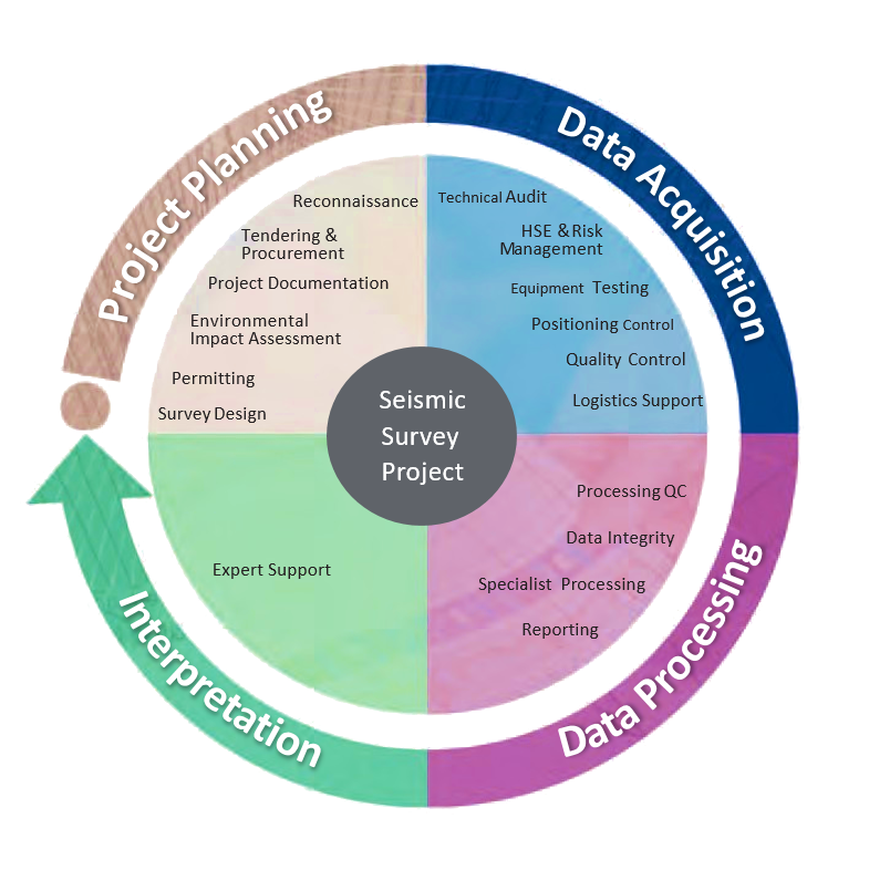
IES provides experienced seismic data processing consultants for the field processing QC or for the final processing phase. Our processing personnel work with our navigation and data processing specialists, where necessary, to ensure rapid turnaround times and obtain optimum quality data.
Data processing supervision and management ensures that contractors produce the best possible data for interpreters. We have a team experienced in land, marine and transition zone projects.
IES can provide expertise throughout all the key stages of a data processing project: tender preparation and selection of a contractor for data processing, supervision, QC and expert advice during the project.
Specialist processing projects require a tailored data analysis and processing approach so that specific objectives are met. This is applicable for cases of data conditioning for AVO, AVO analysis, and other advanced seismic analysis. We have the in-house expertise and software to undertake this type of analysis.
Crew processing has developed with modern software capability into an industry standard tool to perform quick-look analysis or 'fast-track' final processing. This approach helps monitor the suitability of parameters over diverse terrain and allows near real time decisions on data validity to be made. Our services cover this area as well and our personnel help to ensure that the best possible quality data are obtained.
Integrated Engineering Solutions is the official distributor of specialized software RadExPro in the countries of Central Asia and Azerbaijan.
Specialized software RadExPro is used for quality control and processing of land and marine seismic surveys data, in-depth processing of high-resolution marine seismic surveys, processing of land engineering seismic surveys (Seismic Reflection Method, Seismic Refraction Method, tomography, MASW), basic processing of VSP.
RadExPro software is a full-featured software for carrying out projects for processing seismic data of any level of complexity, meeting all modern requirements of technical specifications for processing. The software contains field-tested algorithms for optimal field quality control, allowing data processing to be completed in the office. Using the advantages of this software such as flexibility, reliability and simplicity allows you to increase the efficiency of specialists, at the same time maximizing the reliability of the results obtained.
The software is based on fundamentally new proprietary technologies that are ahead in development of standard approaches implemented in well-known foreign analogues. The success of implementing these technologies has been proven in a number of completed projects.
Depending on your specific requirements, you can choose from specialized software packages.
Hundreds of geological and geophysical companies, as well as design and research organizations in more than 50 countries around the world successfully use this software.